


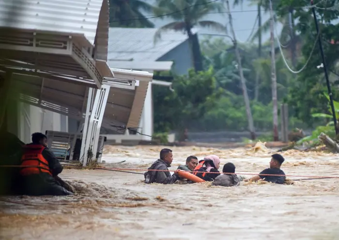
Fresh floods hit North and West Sumatra as communities struggle to recover from last year’s disaster
Fresh floods and landslides have struck parts of North Sumatra and West Sumatra, putting communities at risk once again as many residents continue to recover from the devastating disasters of November 2025. The latest flooding has forced families to leave their homes, damaged essential infrastructure and renewed concerns about the region’s vulnerability to extreme rainfall.
In North Sumatra’s Langkat regency, heavy rain from Sunday night until Monday afternoon triggered flooding that reached more than 1.5 metres in several subdistricts. The rising water submerged sections of the Trans-Sumatra Highway, a vital transport route connecting North Sumatra with Aceh, causing major traffic disruptions. Although no deaths or injuries were reported in the affected areas, hundreds of residents were forced to seek safety elsewhere, while bridges and other public facilities sustained damage.
For residents who experienced last year’s catastrophe, the rising water brought back painful memories. Mardiansyah Putra, who lives in Besitang district, said floodwater began entering his home in the early hours of Monday. His family initially remained inside, hoping the situation would improve, but eventually decided to evacuate around midday when the water reached chest height.
Speaking to The Jakarta Post, Mardiansyah explained that his family moved to a relative’s home because the water continued to rise and they feared for their safety. Although the latest flooding was not as severe as the disaster in late November 2025, the experience remained deeply distressing.
His account reflects the emotional toll of repeated disasters. For families who have already lost property, endured displacement or spent months rebuilding their lives, every new spell of heavy rain can bring renewed anxiety about whether their homes will remain safe.
According to the Langkat Disaster Mitigation Agency, 310 families had evacuated by midday on Monday. Agency head Muhammad Ansyari said the floods had also damaged infrastructure across the regency, creating additional challenges for affected communities.
In Bukit Mas village, floodwaters damaged power cables, leaving residents without electricity. A bridge connecting Pantai Pulo and Sukaramai hamlets was also swept away, disrupting movement between the two communities. Residents temporarily placed wooden planks across the damaged crossing to allow motorcycles to pass, Ansyari said, highlighting the difficulties people face when essential transport links are lost.
The situation has also deteriorated in West Sumatra, where torrential rain triggered floods and landslides in the provincial capital of Padang and neighbouring South Pesisir regency on Saturday. Hundreds of residents were forced to evacuate as floodwaters damaged homes and affected local infrastructure.
In Padang, 627 people sought refuge in temporary shelters after flash floods swept through the city. Five houses were destroyed, while more than 120 others were inundated. The latest disaster struck areas that had already suffered severe flooding the previous year, raising questions about how quickly damaged river systems and protective infrastructure can be restored.
Padang Mayor Fadly Amran said sediment accumulation had made rivers shallower, increasing the likelihood of water overflowing during periods of intense rainfall. He also noted that some of the affected areas had experienced flooding three times since last year.
The latest inundation reportedly destroyed temporary embankments installed after the previous disaster. The city administration is pursuing a longer-term approach that includes improvements to upstream river channels, although the project is still awaiting the tender process. Authorities are also working on plans to relocate residents living in areas repeatedly affected by floods.
In South Pesisir regency, flash floods on Saturday night swept away two houses and severely damaged another 11, affecting approximately 4,240 people. The impact extended beyond residential areas, with 12 educational institutions, ranging from early childhood education centres to vocational high schools, affected by mud and debris.
One of the most concerning situations unfolded in Ranah Ampek Hulu Tapan district, where floods and landslides left a village isolated for two days. Ten residents were buried under debris, according to district head Agnes Dheno Arnas. She said all those trapped had been evacuated and residents who sustained serious injuries had been taken to medical facilities.
The isolation also disrupted transportation and the movement of essential supplies. Motorists, logistics truck drivers and fuel transporters were stranded in the district for two days, with some beginning to run low on food. Such disruptions can quickly become a serious concern when roads are blocked and communities are cut off from outside assistance.
Experts warn that the danger may extend beyond the immediate effects of rainfall. Hatma Suryatmojo, a forest hydrology and watershed management expert at Gadjah Mada University, explained that landslides triggered by the November 2025 disaster had left debris in upstream areas. Heavy rain can carry this material downstream, potentially obstructing river channels and increasing flood risks.
He noted that steep slopes and narrow river valleys in parts of Sumatra make the region particularly vulnerable. Landslide debris can block waterways and create natural dams. When water accumulates behind these obstructions, a sudden collapse can release large volumes of water and trigger dangerous flash floods downstream.
Hatma called for the government to reassess land-use planning according to disaster risk. He argued that areas with high vulnerability should be restored as protected zones, allowing damaged ecosystems to recover and reducing the likelihood of future disasters. In his view, disaster risk must become a central consideration in spatial planning rather than a secondary factor.
The latest floods underline a difficult reality for communities across Sumatra: recovering from a disaster requires more than clearing debris and rebuilding damaged homes. Rivers, hillsides, roads and protective infrastructure must also be managed in ways that reduce the risk of another catastrophe.
For families who have already endured displacement, the consequences of repeated flooding extend far beyond damaged buildings. Children may lose access to school, workers may be unable to earn a living, farmers can see their livelihoods disrupted, and entire communities may face uncertainty every time heavy rain returns.
Emergency shelters, evacuation support and infrastructure repairs remain essential, but long-term protection is equally important. Better watershed management, stronger disaster preparedness, risk-based development planning and the restoration of vulnerable landscapes could help communities become more resilient.
Ultimately, these floods are a reminder that disaster recovery cannot end when the water recedes. The real measure of recovery is whether people can return home without living in constant fear of the next downpour. For North Sumatra and West Sumatra, protecting lives will require both immediate assistance and lasting solutions that address the underlying risks.